Sunday, July 11, 2010

We are moving!


In order to improve our website, we are proceeding to some changes. Visit us at our new address (http://www.publicarchaeologyexperience.wordpress.com/) or on our Facebook page!

Tuesday, January 12, 2010

Presentation of the Project


In 2004, 137 acres of land, formerly part of the historic Acadian village of Beaubassin from 1672 to 1750, were acquired by Parks Canada and protected the following year as a National Historic Site of Canada. Located on the Fort Lawrence Ridge, adjacent to the New-Brunswick – Nova-Scotia border, the lands also include Fort Lawrence National Historic Site (1750-1756), designated in 1926. The property encompasses a significant portion of the former Acadian village, including the ruins of the Acadian cemetery and Fort Lawrence. The architectural ruins and features of the village, burned in 1750, attest to the Acadian way of life and to the geopolitical struggle between France and England for the control of Canada.


The Historic Sites and Monuments Board of Canada approved the following statement of commemoration for Beaubassin on June 25th 2008: “ A thriving Acadian settlement here became a pivotal site in the struggle between Great Britain and France for control of the Isthmus of Chignecto region. The village, under British rule since 1713, was burned by the French in 1750 to force the inhabitants into nearby French-controlled territory. The site’s extensive archaeological resources, which include remarkable glass and ceramic artefacts and charred building remains, reflect both the Acadian way of life and the destruction of this village. Beaubassin remains a silent witness to the clash of two empires for power in North America.”


In 2006, Parks Canada began work on the development of a management plan for the Chignecto Isthmus National Historic Sites, including Fort Lawrence and Beaubassin. At this time, local communities and organisations expressed a vivid interest and willingness to participate in the development of the sites, particularly Beaubassin. In 2007 and 2008, stakeholders of the Chignecto Isthmus were invited to information and exchange meetings to ensure good collaboration and buy-in for the national historic sites of the Chignecto Isthmus. Each group expressed their wish to see a long-term approach for the development of a public archaeology program by Parks Canada.

The aim of this blog is to provide you with information should you wish to participate, and updates on the dig if you already did!

Please feel free to leave us comments or ask questions!

Thursday, August 6, 2009

Registration and information

Beaubassin, a newly acquired site by Parks Canada, will unearth through the "Public Archaeology Experience" artifacts attesting to the Acadian way of life before the Deportation. The Experience will also include Fort Lawrence, a British fort constructed within the former Acadian village of Beaubassin, which commemorates the struggle between the French and the British Empires.


Schedule for the day:

9:00 a.m. Welcome and orientation at Fort Beauséjour - Fort Cumberland National Historic Site.
9:10 - 10:10 a.m. Introduction to archaeology and historical overview.
10:30 - 12:00 p.m. Participation in excavation activity at Beaubassin and Fort Lawrence.
12:00 - 12:45 p.m. Lunch (on your own).
12:45 - 3:00 p.m. Excavation and archaeological work continues for all participants.
3:00 - 3:30 p.m. Wrap up and finale


Registration requirements:

• Registrants should be in good physical condition to participate in the excavation. Activities will proceed at a comfortable pace, though some physical exertion will be required. The on-site field lab will provide the opportunity to participate in less strenuous archaeological activities.
• It is not required to have prior archaeological experience.
• Registrants must be at least 17 years of age in order to participate.


Dates: July: 22, 23, 24, 25, 29, 30, 31 August: 1, 5, 6, 7, 8, 12, 13, 14, 15.

Registration Form:

Please select the preferred date for your personal archaeological experience: (x)

July:
__22 __23 __24 __ 25
__29 __30 __31

August:
__ 1
__5 __ 6 __ 7 __ 8
__ 12 __ 13 __ 14 __ 15
The experience occurs on thurdays, fridays, saturdays and sundays.


Name: _____________________________________________________________
Home Address: ______________________________________________________
Street
______________________________________________________
City Prov/State Postal Code/ZIP

Day Phone: ( ) _______________ Evening Phone: ( ) ________________

Email: ______________________________________________________________

Please inform us of any allergies or medical conditions: ________________________

______________________________________________________________________

Any details or interests that we should be aware of: _____________________________

_______________________________________________________________________


Registration Fee: $36.70 Canadian ( price includes taxes)

Fee Breakdown: Introduction to archaeology (training theory and practice): $14.70
Excavation and Archaeological work: $22.00
Total: $36.70

Fee Total:

Number of Participants ____ X $36.70 = ___________

Total Registration Fees: ___________

We prefer participants register early as spaces are limited.
Full Payment must be received with the registration form.

Payment Options:

By Mail: Please send your completed registration form with payment to:

Fort Beauséjour-Fort Cumberland National Historic Site of Canada
111 Fort Beauséjour Road
Aulac, New Brunswick
E4L 2W5

By email: Send completed registration form to fort.beausejour@pc.gc.ca
By Fax: Send completed registration form with credit card information to
(506) 536-4399.
By Phone: Call the site at (506) 364-5080 to receive a registration form.

I would like to pay by:

__ Cheque (please make payable to Receiver General of Canada )
__ VISA __ MasterCard __ American Express __ Cash

Card Number: __ __ __ __ __ __ __ __ __ __ __ __ __ __ __ __
Name on Card: _______________________________________ Expiry Date:_ _/_ _

Signature:___________________________________________


Cancellation Policy:

Please inquire about the status of the archaeology program before making any travel arrangements. We reserve the right to withdraw the "Public Archaeology Experience 2008" or make changes to the program at any time, without penalty.

If you wish to cancel your reservation, a refund will be granted. The participant must advise the site in writing, at least 48 hours prior to their chosen date.

Registration Policy:

Each "Public Archaeology Experience" is limited to 12 participants per session. All spaces are granted on a "first register and pay, first serve" basis.
As space is limited, we will immediately contact and inform registrants if their chosen session has already been filled. Other sessions may still be available.

Clothing and Weather Conditions:

The months of July and August are usually warm and pleasant, but participants should be prepared for rainy and cool conditions. There is also a fair amount of wind, and registrants should dress accordingly. It is recommended that participants be prepared to dress in layers, and should also bring rain gear, comfortable shoes, a wide brimmed hat, and sunglasses. Sunscreen and insect repellent will be provided, but some may opt to bring their own brands.

It is recommended that participants have up to date tetanus vaccinations prior to arrival.

Lunches:

Participants are asked to bring their own packed lunches. Snacks and bottled water will be provided. Eating establishments are located within a few minutes drive.

Artifacts:


Participants will have the opportunity to discover artifacts from the pre-deportation Acadian period, as well as that of British occupation. These artifacts will remain the property of Parks Canada, who will ensure their commemorative integrity. The artifacts will be studied to further the historical and archaeological understanding of the area for all Canadians.

Questions? Please contact us at fort.beausejour@pc.gc.ca or call (506) 364-5080.

The Beaubassin/Fort Lawrence region before 1755

A traveller in the Beaubassin/Fort Lawrence region would find it difficult to imagine that this region was the theatre of events that left their mark in the annals of Canada, or indeed of the entire northeastern part of North America,in the seventeenth and eighteenth centuries. However, this is where the fate of the Acadians and the French colonies in North America played out during this period. But how does one explain how what is today such a peaceful farming region had such a tumultuous past, and moreover, understand that all that now remain of the Acadian presence in the region are the archaeological traces of their settlements? In the following paragraphs, we will try to answer these questions by shedding a little light on the first century of European presence in the Beaubassin/Fort Lawrence region.


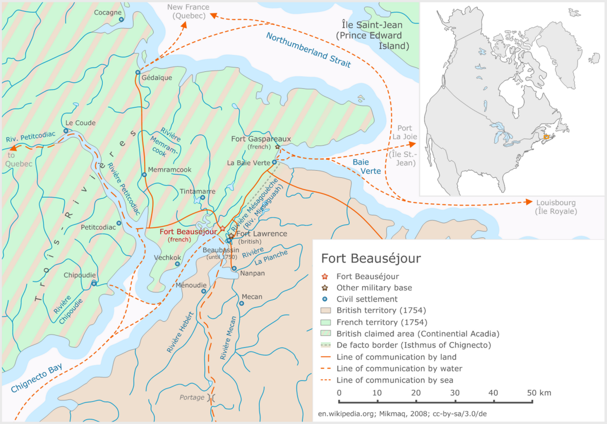
To start off, however, some explanation should be given of the place names in the region. First, there is the Isthmus of Chignecto, which includes all the territory now corresponding to the region around Sackville in New Brunswick and Amherst,including Maccan, Nappan, River Hebert and Minudie, in Nova Scotia. Old French and English documents use both Chignectou and Chignecto to describe this region, though the French also often refer to it as Beaubassin, from the name of the religious parish that included the entire district. Beaubassin also corresponds to the village known today as Fort Lawrence. The Acadians and French also called this village Mésagouèche, from the river of the same name, now known as the Missaguash River, which forms the border between the provinces of New Brunswick to the westand Nova Scotia to the east. Its geographical location gives the Isthmus of Chignecto a major strategic advantage because it is situated between two bodies of water, the Bay of Fundy to the south and the Gulf of St. Lawrence to the north. Since time immemorial, First Nations communities have used the waterways and portage routes connecting these two shores. Because of the region’s large expanses of marshlands, game was abundant and the high tides supplied the fish and shellfish necessary for the Aboriginal people’s diet. Indeed, the first Europeans to come to the region benefited greatly from their knowledge of the area and realized the region’s strategic importance. In any case, although the first contacts between these two peoples were in the sixteenth century, when Portuguese and other explorers visited the region, only in the seventeenth century, when the French arrived in Acadia, did the Isthmus of Chignecto region attract its first European colonists, and they settled here quite late. Colonists from the Port Royal region began to settle in the area in the 1670s to exploit its immense marshlands. Other colonists of French origin settled there at the same time, but they came from the St. Lawrence River area or Canada, by way of the Gulf of St. Lawrence and the portage connecting it to Beaubassin, the name given to this new colony. These colonists accompanied their seigneur, Michel Le Neuf de LaVallière, who had obtained a large grantor seigneurie from the governor of Canada or New France, who believed that the Isthmus of Chignecto region was under his jurisdiction. Thus, even before the English or British arrived there, there was a certain ambiguity about this region that straddled two French colonial administrations.


The beginning of the new colony was marked by numerous problems, including some with the seigneur of Beaubassin, who served as Lieutenant-Governor and Governor of Acadia. One colonist was tried on charges of sorcery, while another colonist was accused of having gotten the daughter of the seigneur, Governor La Vallière, pregnant. This led to the departure of several of the families who had come from Canada. During the War of the League of Augsburg and the War of the Spanish Succession at the turn of the eighteenth century, the new settlement at Beaubassin was sacked twice, in 1696 and1704, by militia men from New England on incursions into Acadia. As well, in 1710 Port Royal, the capital of this French colony, fell definitively into British hands. With the Treaty of Utrecht in 1713, France ceded Acadia as defined by its former boundaries to Great Britain. Were the colony at Beaubassin and the surrounding region within these former boundaries, since they were considered to be part of Canada? This ambiguity in the minds of the settlers in the region did not bode well for the new British administration at Port Royal. First, the distance between them made the British colonial authorities’ task more difficult. Apart from the independent spirit that had developed among the settlers in the Beaubassin region, the authorities had to deal with a population of rather dubious allegiance. When the authorities tried to make the settlers swear an oath of allegiance to the King of Great Britain, they were met with a categorical refusal. After a few years of negotiations, they swore a conditional oath that released them, among other things, from bearing arms against the French and the Aboriginal people in time of war. Moreover, since they were used to trading with New England under the French administration, the settlers in Beaubassin turned their eyes toward the new French colonies in the region, Île-Saint-Jean and Île-Royale and especially the fortress town of Louisbourg, established in the early 1720s.


During the long period of peace between France and Great Britain lasting until the mid-1740s, the Beaubassin region under went great expansion because of this trade, to the great displeasure of the British authorities in Port Royal. In 1744, the stakes changed radically with the declaration of the War of the Austrian Succession, which again saw Great Britain and France on opposite sides of a conflict.The French mounted four expeditions against Port Royal to become masters of their former colony, Acadia, and almost all of them were staged from Beaubassin. The French troops even established a permanent base in the region to ensure the success of these plans for reconquest. During the negotiations leading to the signature of the Treaty of Aix-la-Chapelle, which put an end to the War of the Austrian Succession in 1748, it was agreed to set up a commission to settle once and for all the question of the former boundaries of Acadia, left hanging after the signing of the Treaty of Utrecht some 25 years earlier. Before this commission even had time to sit, the French and British wanted to strengthen their positions in the region in order to further their claims.Thus, in the fall of 1749, French troops from Canada built a little blockhouse at Pointe-à-Beauséjour, on the west bank of the Mésagouèche River, claiming all the territory to the west and north as part of Canada or New France. The British, on the other hand, were not comfortable with the Acadians settlers, those in the Beaubassin region as well as elsewhere in Acadia, who, according to them, were not subjects who could be counted on in case of war because of the neutrality they had shown during the French expeditions against Port Royal or the colony during the War of the Austrian Succession. Therefore, they decided to adopt a new policy or a different approach toward this population by requiring the settlers to swear an unconditional oath of allegiance that would force them to bear arms against any aggressor, whether French or Aboriginal. Finally, to ensure better control over this population that they considered disloyal, they decided to build fortifications throughout the colony starting, in the summer of 1749, with the founding of Halifax, the new seat of the British administration. More fortifications were built in the Grand Pré or the Minas Basin area, and Beaubassin was to be next when it was learned that the French were already there. In the spring of 1750, a British expedition was sent from Halifax, under the command of Major Charles Lawrence, to drive the French from the isthmus. Since there was no well-developed network of roads, the expedition arrived by sea to face the French troops, supported by their Aboriginal allies and the Acadians from the region of Beaubassin. Faced with a well-armed opponent, Lawrence and his troops had to retreat and temporarily accept the presence of these so-called intruders on lands that they believed belonged to them. At the approach of the British fleet, the French had given the order to burn the village of Mésagouèche or Beaubassin, telling the settlers to cross to the west bank of the Mésagouèche River into the territory that they claimed as part of Canada or New France. This event, along with those surrounding the new British colonial policy in Acadia, caused the exodus of thousands of Acadians and thus represents the beginning of the Grand Dérangement or the Great Upheaval, since nearly one fifth of the total population of Acadia was disturbed in 1749-1750, more than five years before the Deportation. In September 1750, Major Charles Lawrence commanded another expedition,much stronger this time, which the French troops could not resist. The British managed to get as far as Beaubassin and erect a fort, which they called Fort Lawrence, on or near the site of the parish church that had been burned in the spring with the rest of the village.


The French then gave the order to burn all the other villages to the east of Beaubassin, and thus in British territory, swelling the ranks of the families who been living as refugees on the west bank of the Mésagouèche River since spring. To make the situation even worse, the entire harvest was burned in the barns. Even though the settlers had brought their cattle across the river with them, they had no more fodder for them and had to slaughter them through the following fall and winter. Without this important source of food, they had to live on the charity of the King of France for the next five years, that is, until the fall of Fort Beauséjour, built by the French in 1751. In the meantime, this population of Acadian refugees continually complained to the French authorities, who had forced them to leave their settlements and their lands,which were now on territory recognized as British by the French, and to which the refugees wanted to return.The Acadians found themselves this difficult situation until the beginning of June 1755, when a British expedition commanded by Lieutenant-Colonel Robert Monckton and made up of around 2,000 militiamen from New England and a few hundred regular British troops arrived before Fort Beauséjour. The ensuing siege only lasted two weeks before the 150 or so besieged regular French troops and 150 Acadians laid down their arms. Shortly thereafter, in Halifax, the Acadians’ fate was sealed by Lieutenant-Governor Charles Lawrence and his council: the entire Acadian population, not only in the Beaubassin region but also all over Acadia,would be deported to the Anglo-American colonies. Thus on August 11, 1755, over 400 Acadian men and boys were arrested and imprisoned in forts Lawrence and Beauséjour, now called Fort Cumberland.Over two months later, a little over 1,000 men, women and children sailed away on ships transporting them to the colonies of Georgia and South Carolina. Most of them never saw the land of their birth again.However, many Acadians from the Beaubassin region avoided deportation in 1755 and took refuge in French territory,especially Île-Saint-Jean. Others escaped to Canada or remained in what is now the province of New Brunswick, waging a partisan resistance against the British troops stationed at Fort Cumberland and elsewhere. After the fall of Québec in the fall of 1759, however, several hundred of these resistance fighters surrendered with their families to the British authorities.Thus over 300 Acadians were kept prisoner in Fort Cumberland or in makeshift shelters built near the fort. They remained in this precarious situation until the late 1760s, when they were allowed to settle elsewhere, including the Memramcook area in southeastern New Brunswick and Cumberland County in Nova Scotia. In this way, nearly a century after their ancestors settled in the Beaubassin region in the1670s, these Acadians were able to lay the foundations of a new Acadia.Today, all that remains of the Acadians’ stay in Beaubassin/Fort Lawrence are the traces of their village, burned in the spring of 1750. Thanks to Parks Canada’s public archaeology program, we are uncovering the remaining evidence of this Acadian presence in Beaubassin/Fort Lawrence before 1755.


This is not a pipe


While at Beaubassin and Fort Lawrence one of the most common artefacts you are likely to find is a clay pipe fragment, or more precisely many clay pipe fragments. There are many reasons for the overabundance of clay pipes found on Colonial dig sites and almost all of these reasons can be traced back to the sheer amount of smoking which took place in this time. Smoking was not simply limited to adult males; it was common among women and children as well and so when the amount of smoking pipe is discussed it is wise to remember that “amount” refers to not only how much an individual would have smoked tobacco but also how much of the population would have smoked tobacco overall.

When tobacco smoking first popularized in Europe it was believed to be a type of panacea, curing everything from ulcers to respiratory problems to bites from venomous beasts, and even more. Because of this it was extremely common for everyone to smoke. The popularization of smoking of course lead to a high demand of clay pipes which meant that they were quickly being mass produced for the public. Clay pipes are breakable and most of them were cheap and considered to be fairly disposable, when one pipe broke it was simply discarded and replaced with a new one.

With this in mind, there are pipe stems which have been found at Beaubassin and Fort Lawrence and many other sites where there is a defined grooving in the clay which would have been caused by the wearing away of the pipe stem by the person who was smoking it. These indentations can sometimes be very subtle or other times quite pronounced.


On an archaeological dig site pipes can be extremely useful in helping determine an approximate date for the site as they themselves are fairly easily dateable in many different ways. The most accurate way to date a pipe is to look at the pipe bowl and its heel or spur. The way in which these parts of a pipe were shaped and sized varied over time in a fashion which is quite easy to date now.


Unfortunately it is far less common to find a pipe bowl in the condition necessary to date in this way. Another, less accurate way to date pipes is with the stem which is the most common part of a pipe found. This way uses specific sized drill bits, which are slid into the hole of the pipe stem (gently without a lot of force), the size of the drill bit corresponds to a date range and so this gives archaeologists a range of dates to look at for a site.


http://en.wikipedia.org/wiki/The_Treachery_of_Images

Article written by Miranda Romkey, student in archaeology at Memorial University, Newfoundland

Tuesday, July 28, 2009

Gunflints


The image above shows a gunflint discovered at the Beaubassin/Fort Lawrence archaeological site. A gunflint was used to create a spark to light the gunpowder inside the barrel of a gun, to propel the shot. Gunflint production started in the 1600’s with the invention of snaphance guns (Lenk 1965).


All gunflints were manufactured mainly in France and England, and then imported (Woodward 1960). Usually, English flints are dark grey to black whereas the French flints are easily distinguished by their honey-yellow or blonde color. It was usually held intact by a strip of leather or lead.


Natives utilized gunflints differently than Europeans. The Natives fired and retouched their gunflints bifacially (Witthoft 1966), while Europeans worked their gunflints unifacially. In the archaeological record, a gunflint worked bifacially most likely has been utilized by Natives. Gunflint may also have been traded with Natives, who found these objects very useful. The next image shows a scraper, which is an aboriginal tool similiar to the gunflint that was used either for hideworking or woodworking purposes:


To see the flintlock mechanism: http://arc.id.au/Flintlock.html


Article inspired by Colin QUINN, «An experimental use-wear and functional analysis of gunflints», [PDF], Lambda Alpha Journal, Department of Anthropology, University Notre Dame, Volume 34, 2004, p.60-71.

http://soar.wichita.edu:8080/dspace/bitstream/10057/789/1/LAJ34,2004.64.pdf

Wednesday, July 22, 2009

Staffordshire pottery

Staffordshire pottery is pottery that is produced in the Staffordshire potteries area of the United Kingdom. This area is in the Midlands - the potteries used to centre around six separate towns (Burslem, Fenton, Hanley, Longton, Stoke and Tunstall) which are now Stoke on Trent.

The area really came into focus as the powerhouse of pottery production in the UK in the 1700-1800s but, the truth is, that this has been a significant pottery producing area for centuries. Staffordshire has plenty of clay, lead, salt and coal in the area which made it a perfect place for pottery production.

In early days potters would simply dig clay up from roads which is thought to have led to the term ‘potholes’! It was quite common for farmers to make pottery at this stage - the land was not good enough for them to make enough money from farming so many worked as potters as a sideline. Gradually many of the farmers moved into full-time pottery production.

In its heyday there were hundreds of manufacturers producing all kinds of pottery in Staffordshire - some of whom became famous names and some of whom are still producing pottery to this day. Well known pottery companies include:

• Wedgwood
• Spode
• Minton
• Aynsley
• Doulton
• Twyford

Here are some Staffordshire pottery fragments found at the Beaubassin-Fort Lawrence archaeological site.


Complete article: http://www.staffordshire.co.uk/Staffordshire_Pottery_History.htm